In June 2013 we cycled the Cyclists's Path, starting south of Maastricht and ending at the Wadden Sea by Pieterburen. The only existing guide book is in Dutch. Is this a problem if you don’t understand the language? And what does the route have to offer? We decided to find out.
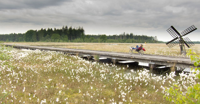
 A wooden bridge takes you across the marshes of the Grolloërveen. Photo © Holland-Cycling.com
The success of the most popular Dutch hiking trail, the Pieterpad, which starts at the Wadden Sea by Pieterburen and ends just south of Maastricht on top of the Pietersberg, inspired the makers of the Cyclist’s Path to come up with a version of this route for bikes. Although the two routes occasionally overlap, the Cyclist’s Path is an independent route that should be judged on its own merits.
The Cyclist’s Path takes you from south to north, making the best use of the prevailing south-westerly wind. It is not signposted or marked on cycle maps. The only existing guide book is in Dutch. Is this a problem if you don’t understand the language? We decided to find out.
Documentation

The first impression of the guide book is good. The photos and illustrations promise a nice, varied route and the maps appear to be usable without the route description. Some hotels and campsites along the route are marked on the maps, but nowhere near every option available.
For those of you who have mastered some Dutch, the book gives a lot interesting background information on the landscape and history of the regions you come through. It’s not exactly beginners’ Dutch, but if you can manage to work your way through the texts, it’s well worth the effort.
As soon as we set out, we realised that using just the maps in the guide book was not going to be as straightforward as we thought. Despite their small scale, they give little topographical information: no distinction is made between a main road, or just a cycle path and a left hand turn which seems to be in the middle of nowhere, might actually be after a clear landmark such as a football field or an industrial estate. Finding the route without these details was really hard - we got very frustrated from having to backtrack all the time. Using just the maps is clearly not an option.
Combining the maps with the GPS tracks, which can be downloaded for free from the publisher’s website, would have been the obvious solution. However, not everybody has a GPS system (we didn’t), so we tried an alternative: using the maps from the guide book together with our regular cycle map. This definitely worked for us - though a next time we’ll make sure we draw the route in our regular cycle map so we don’t have to mess around with two books.
Route
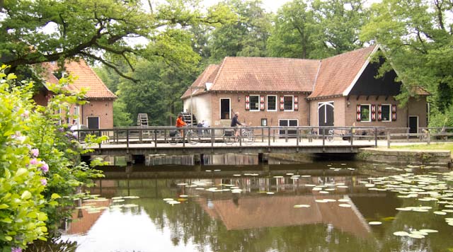
 The route takes you through the Singraven estate. Photo © Holland-Cycling.com
As you would expect from any good cycle route, the Cyclist’s Path takes you along scenic cycle paths and country lanes, avoiding busy traffic. You come through some of Holland’s most rural and sparsely populated regions. It’s amazing how few motorways and big towns you encounter.
As the route doesn’t follow the numbered cycle network and isn’t signposted, there are parts where you pretty much have the road all to yourself.
To show you some places of interest, a couple of times the route takes you over footpaths where cycling is not allowed and you have to walk. You can understand why, but it’s not always convenient if your bike is fully loaded. There is always an alternative option, which is marked on the map if not self-evident.
Main focus: the landscape
The makers of the route are very much interested in the Dutch landscape. How was it shaped over time by nature and man? How did the landscape in turn shape the lives of people? If there is any remarkable geological feature in area, they’ll take you there.
For example, just north east of Nijmegen the route goes over the German border to Hoch Elten, which lies on a 65-metre high hill formed by Ice Age glaciers and the River Rhine. Further up north the Cyclist’s Path closely follows the German border, which used to be marshland: an ideal natural barrier. Now most marshes have been turned into agricultural land, but dotted along the border there are still nature areas that show you a glimpse of the past - and even some wild flamingos!
Some geological features are described in detail in the book, but from your bicycle you hardly notice them. Reading the map, we had looked forward to cycling along the picturesque River Dinkel in Twente. We were a bit disappointed that we only got to see the river itself when crossing it. Where we were supposed to cycling right along the river banks, there was no path we could find.
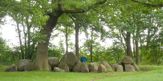
 Megalithic tomb in Rolde. Photo © Holland-Cycling.com
Sights
The route takes you past numerous places of historical and cultural interest. Our favourites were the 12th-century castle at ’s Heerenberg, the watermill on the Singraven estate and the megalithic tombs, or hunnebedden in Rolde - the Dutch equivalent of Stonehenge. We were also fascinated by the weird combination of oil pump jacks and cows at Schoonebeek.
As the route’s main focus is the landscape, it doesn’t make an effort to show you all the touristic sights in the area. A perfectly legitimate choice, but it is a shame no mention is made of the Hooghalen Radio Telescope and Westerbork transit camp, which are less than 10 km off the route - just outside Hooghalen (Drenthe). Anne Frank was among the Jews taken here during WWII before being deported to extermination camps. You definitely don’t want to miss this if you’re in the area - you can cycle right through the site.
Are you more interested in the sights? You can also cycle from Maastricht to Groningen following several sections of the LF routes [link]. They focus more on showing you the touristic sights, but as a consequence take you through more towns and villages. The LF routes are signposted and therefore used by more cyclists. For visiting Hooghalen it doesn’t make any difference which of the two routes you choose as the detour is more or less the same.
Conclusion
The Cyclist’s Path is a varied route that takes you through remote parts of Holland that are quiet and not so well-known. It is not signposted, so you have to rely on your own navigation skills. The only existing guide book is in Dutch. If you don’t understand the language, the guide book on its own is not enough. We recommend using the maps in combination with a regular cycle map or the GPS tracks provided by the publisher.
The main focus of the route is the Dutch landscape, making it an ideal route for nature lovers. Along the route there are numerous places of historical and cultural interest. However, if you are mainly interested in sightseeing or don’t want to rely on your map reading skills, you can probably better follow the LF routes that go through the same area. LF routes are signposted and focus more on showing you the touristic sights, but as a consequence you do go through more towns and villages.
For more on the route (and more pictures!), go to Cyclist's Path
Cyclist’s Path (Fietserpad) |
|
| Route: | South of Maastricht - Wadden Sea by Pieterburen |
| Distance: | 574 km |
| Guide book: | Het Fietserpad, Uitgeverij Elmar, 7th edition [no longer in print] |
| GPS tracks: | No longer available |

